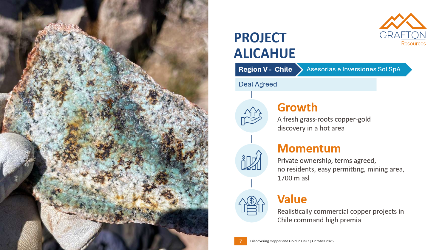
Alicahue
Alicahue Copper Project Overview
The Alicahue Copper Project is located at an altitude of approximately 1,700 metres in the Andean Cordillera, just 140 km north of Santiago and 6 km from paved road access. The project covers 3,500 hectares of mining concessions in a northwest (NW) and southeast (SE) block. The area is surrounded by mining companies such as Newmont, and Los Andes Copper. The project area has never been subjected to systematic copper exploration until recent years. The Vendors assessed the area for copper potential and used historical (BRGM) stream sediment anomalies as a starting point for systematic, traditional exploration. Values of up to 407 ppm Cu and 130 ppb Au in stream sediments are found in the area. Exploration work to date has included geological mapping, and rock and soil geochemistry.
Based on 1990’s BRGM Stream-Sediment Survey copper and gold anomalies, soil sampling grids in the anomalous catchment areas were undertaken. The soil sampling identified sets of anomalies (> 300 ppm) at least 1.7 km long and 1.1 km wide in both the NW and in the SE blocks. The main anomalies are still open to the north and the east.
Mapping in the NW block has identified mineralization that Grafton Resources believes has the potential for bulk, disseminated copper mineralization in the north and high-grade Cu-Au-Ag IOCG-shear zone to southwest. In the SE block, Grafton Resources believes that there is potential for deeper porphyry-copper deposit formation, as indicated by the presence of UST textures, tourmaline breccia pipes and epithermal veins.
Exploration Target
Grafton Resources management consider Alicahue to host newly identified Cu-Au mineralization. The project lies in the southern projection of the Paleogene metallogenic belt of Chile, which hosts large porphyries such as El Salvador, Escondida, and Chuquicamata.
This discovery could extend this fertile belt at least another 100 km to the south and open a new exploration frontier in Chile. The combination of geology and geochemistry points to the potential for a classic porphyry deposit.
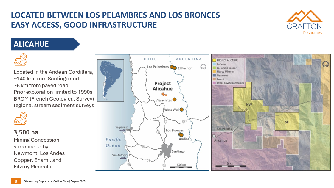
Alicahue - Located between Los Pelambres and Los Bronces easy access, good infrastructure
Located in the Andean Cordillera, ~140 km from Santiago and ~6 km from paved road.
Prior exploration limited to 1990s BRGM (French Geological Survey) regional stream sediment surveys 3,500 ha.
Mining Concession surrounded by Newmont, Los Andes Copper, Enami, and Fitzroy Minerals.
BRGM stream sediment data
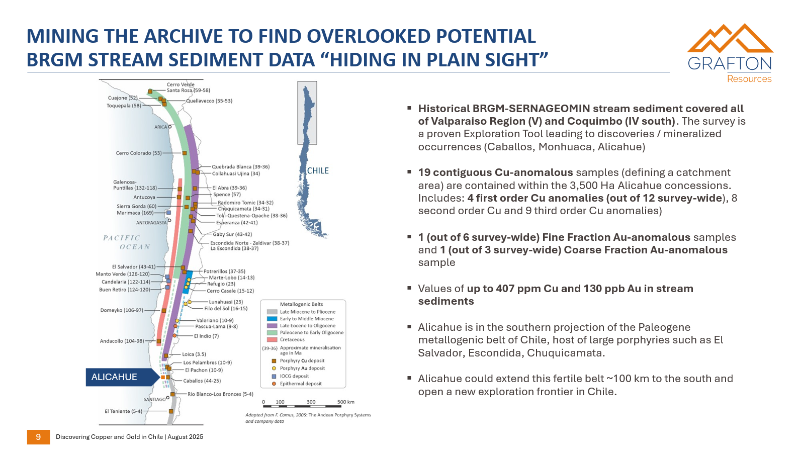
Historical BRGM-SERNAGEOMIN stream sediment covered all of Valparaiso Region (V) and Coquimbo (IV south). The survey is a proven Exploration Tool leading to discoveries / mineralized occurrences (Caballos, Monhuaca, Alicahue)
19 contiguous Cu-anomalous samples (defining a catchment area) are contained within the 3,500 Ha Alicahue concessions. Includes: 4 first order Cu anomalies (out of 12 survey-wide), 8 second order Cu and 9 third order Cu anomalies)
1 (out of 6 survey-wide) Fine Fraction Au-anomalous samples and 1 (out of 3 survey-wide) Coarse Fraction Au-anomalous sample
Values of up to 407 ppm Cu and 130 ppb Au in stream sediments
Alicahue is in the southern projection of the Paleogene metallogenic belt of Chile, host of large porphyries such as El Salvador, Escondida, Chuquicamata.
Alicahue could extend this fertile belt ~100 km to the south and open a new exploration frontier in Chile.
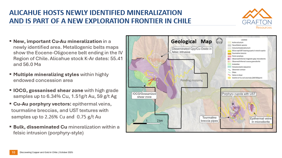
Alicahue hosts newly identified mineralization and is part of a new exploration frontier in Chile
New, important Cu-Au mineralization in a newly identified area. Metallogenic belts maps show the Eocene-Oligocene belt ending in the IV Region of Chile. Alicahue stock K-Ar dates: 55.41 and 56.0 Ma
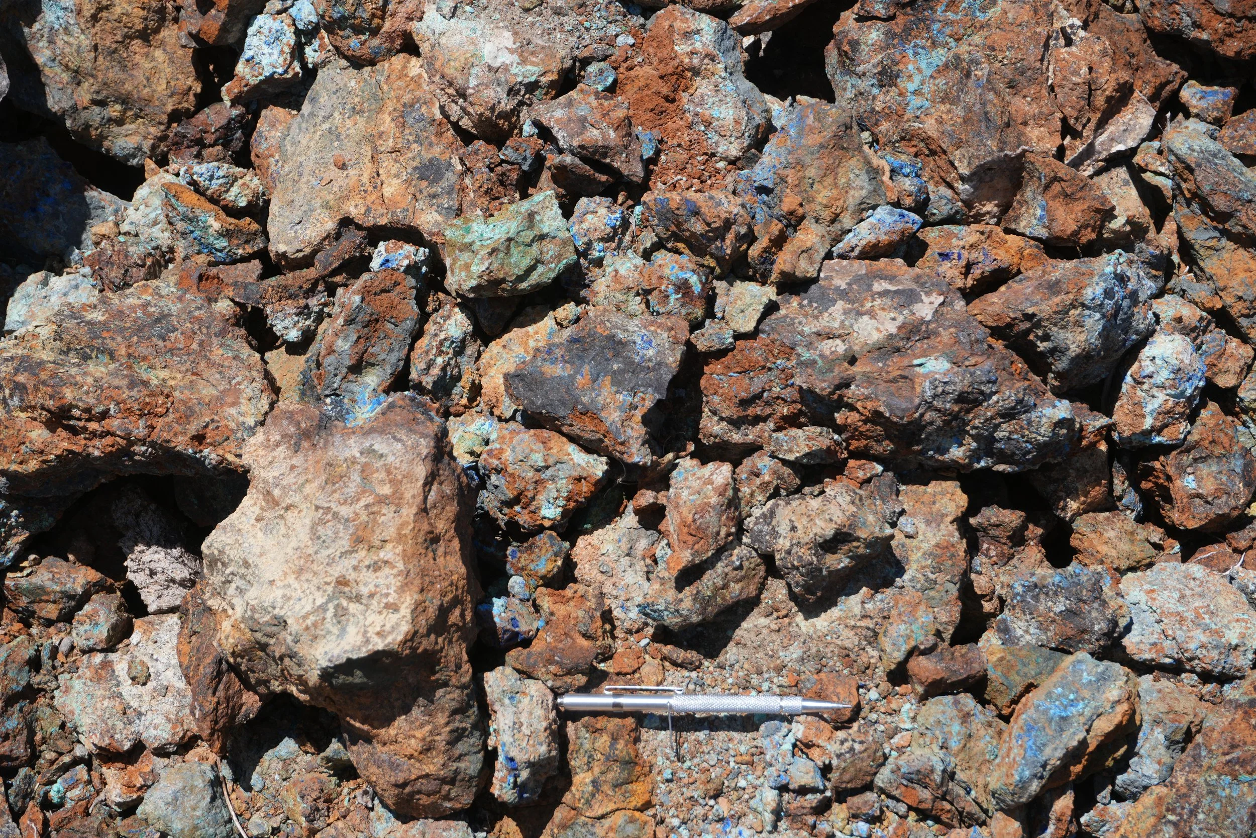
Multiple mineralizing styles within highly endowed concession area
IOCG, gossanised shear zone with high grade samples up to 6.34% Cu, 1.51g/t Au, 59 g/t Ag
Cu-Au porphyry vectors: epithermal veins, tourmaline breccias, and UST textures with samples up to 2.26% Cu and 0.75 g/t Au
Bulk, disseminated Cu mineralization within a felsic intrusion (porphyry-style).
Regional Geology
Project Alicahue is associated to the main pluton of the Fredes Unit, a set of Paleogene stocks of dioritic-monzodioritic, to granodioritic and tonalitic composition. In Alicahue the stock has K-Ar dates of 55.41 and 56.0 Ma (limit of Paleocene- Eocene).
The Fredes plutons are usually differentiated, generating zonation of diverse lithotypes, as observed by us in Alicahue. It is expected that the final stages of the fractioning process tends to generate younger, more aqueous (porphyritic) bodies.
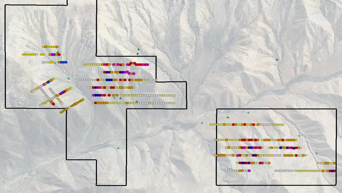
Soil Geochemistry
A total of 493 B-horizon soil samples were collected and prepared at the company’s laboratory in Cabildo.
Samples were dried, sieved at < 80# and assayed by XRF method for 40 elements.
Cu results using the XRF method were validated through pulps assays by AAS.
Soil grids were generally 300 x 75m, with some variations due to topography.
From total Cu-results population, 20% were over 300 ppm and 11% over 400 ppm Cu, with up to 1.995 ppm Cu.
Despite the strong Au SS anomaly and the description of old Au mines in Block NW, no Au assays were performed in the soil samples.